SJC Ewert Road Myths and Facts
By community advocates including Jordan Moldow (San José BPAC Chair). Source: SJC Ewert Road Myths and Facts (also available as a published Google Doc).
“The City of San Jose has approved the closure of Ewert Road to the public and pedestrian access.” — Email from SJC Customer Service
This was privately arranged in this 2021 MOU between the Director of Aviation and the Director of Transportation[1]. No other publicly available documentation or resolutions corroborate the claim that this change in status was “approved”. No stakeholders were engaged, and City Council was not consulted.
“The closure was included as part of planning for the completed Highway 101 Interchange project.” — Email from SJC Customer Service
VTA was the lead agency for this project, and this was not something that was part of their plan or their agreement with the various participating agencies.
Q&A from the US 101/DeLa Cruz/Trimble Interchange Improvement Project Community Meeting on Wednesday, August 25, 2021 [2]:
Q: “Will bicyclists still be able to use the existing route through SJC to the Guadalupe Trail?”
A: Gene Gonzalo, Highway Capital Program Manager: “The answer is yes.”
The publicly available design concepts[3] also clearly show that the design for the Central Expressway intersection includes a two-way bicycle connection between Ewert Road, Central Expressway, and the US-101/De La Cruz interchange[4] trail.
US 101/De La Cruz Boulevard/Trimble Road Interchange Improvements Design Exhibit — Zoomed in on the intersection of Ewert Road, De La Cruz Blvd, and Central Expressway.

Official design exhibit for VTA’s US 101/De La Cruz Boulevard/Trimble Road Interchange Improvements Project, showing the connection point to Ewert Road, from De La Cruz Blvd and Central Expressway. Note the bi-directional crossbike connecting to/from Ewert Road. Also note the lack of designs for any bikeway along De La Cruz Blvd. This connection is solely for Ewert Road.

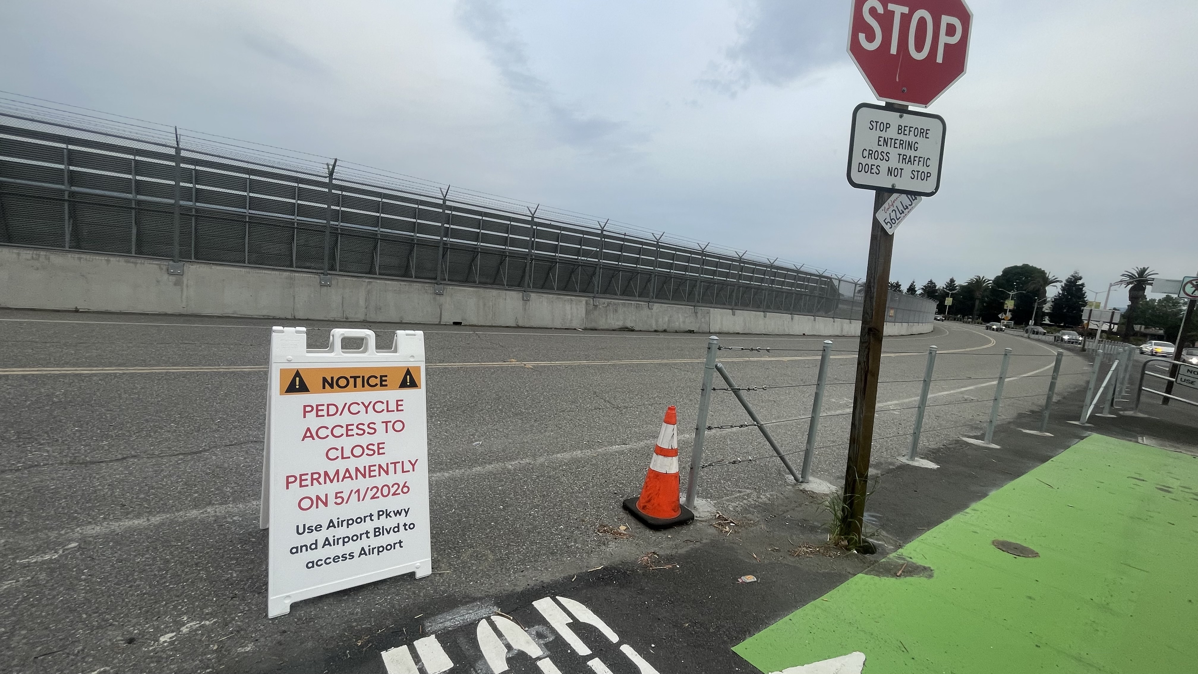
Street view of connection point to Ewert Road, from De La Cruz Blvd and Central Expressway.

Street view of connection point to Ewert Road, from De La Cruz Blvd and Central Expressway. The markings and paint were added as part of the US 101/De La Cruz Boulevard/Trimble Road Interchange Improvements Project. Note the bi-directional crossbike, the bike signal heads, and the STOP / “Stop before entering” signs. Also note the lack of present-day bikeway on De La Cruz Blvd. This connection is solely for Ewert Road.

“Alternate East to West bike and pedestrian access is available via the new Class I bike trail along the Highway 101 interchange connecting De La Cruz/Central Expressway to the Guadalupe River Trail. While this route is longer than Ewert Road, it is designed to offer a [....] more reliable experience” — Email from SJC Customer Service
There are a few distinct travel patterns through this area, each with their own infrastructure needs.
Between North San José and Central Expressway: The new interchange trail does greatly improve connectivity.

Between North San José and Downtown San José: During the dry season, when the Guadalupe River Trail (GRT) is reliably navigable, the GRT is a preferred route, and neither De La Cruz nor Ewert Road are necessary to use. But when the GRT underpass for US-101 is unreliably navigable (which encompasses many rainy months), the interchange path only helps detouring around that flooding when used in combination with Ewert Road. Without Ewert Road, the alternative detour requires biking on N 1st St and then crossing two highway ramps on Airport Parkway.

From Downtown San José to Central Expressway: During the dry season, some cyclists will find it adequate to get from Downtown San José to areas west of the airport via the new interchange trail. Other cyclists, who are trying to commute quickly to Santa Clara for work, find Ewert Road to be preferable to the interchange trail. Ewert Road is flat and direct, while the interchange trail involves elevation gain and a circuitous route. And when the GRT underpass for US-101 is flooded, it is impossible to get to Trimble/De La Cruz without using Ewert Road or riding along the unprotected Brokaw Road and N 1st St near the high-traffic highway ramps.
From Central Expressway to Downtown San José: Similar to the reverse route described above. During rainy months, the De La Cruz to GRT route is not “a more reliable experience”. You might spend much time and effort climbing and descending the interchange trail, then transferring to the GRT and biking south, only to discover that the underpass for US-101 is impassable and you need to double-back to Trimble and then take the more dangerous N 1st St detour route. Whereas if Ewert Road is available, you can assume that the underpass for US-101 might be flooded, and proactively take Ewert Road, avoiding N 1st St.
Between the west side of the airport and the east side of the airport: If airport personnel wish to bike between facilities on opposite sides of the airport, biking along Ewert Road and connecting to Martin Ave is likely a safer and more comfortable option, compared to biking in high-volume traffic along Airport Boulevard and Coleman Ave. The Integrated Final EIR for the 2020 Major Amendment to the Airport Master Plan notes, “To get to the facilities on the west side of the Airport, there are bike lanes on a portion of Coleman Avenue. It would be desirable to have bike lanes on the full length of Coleman Avenue and on De La Cruz Boulevard. Most of the sections without bike lanes are in Santa Clara.” The Airport cannot force Santa Clara to build bike lanes, but the Airport can maintain the existing bike lanes on Ewert Road and include a bike connection through the future Orange Lot / Martin Ave redevelopment.
“Alternate East to West bike and pedestrian access is available via the new Class I bike trail along the Highway 101 interchange connecting De La Cruz/Central Expressway to the Guadalupe River Trail. While this route is longer than Ewert Road, it is designed to offer a safer [....] experience for users of all ages and abilities.” — Email from SJC Customer Service
Ewert Road is also a safe, all ages and abilities facility. It is closed to general vehicles, and the volume of airport vehicles is near zero. Flat, car-free streets are accessible to all ages and abilities.
If traffic volumes do begin to increase with the redevelopment of the Martin Ave lot, it still would not take much investment to maintain its safety. Ewert Road has a single speed limit sign posted, with a 35 mph limit. The Public Streets GIS dataset[5] documents Ewert Road as having a 25 mph speed limit. It should be possible to lower the speed limit to 25 mph or 20 mph, using the provisions of AB 43, to lower the speed limit by 5 or 10 mph. Even with a speed of 25 mph, the narrowness and curvature of the road make it so that the effective speed might be closer to 20 mph. At 20 mph and low traffic volumes, constrained bike lanes are considered to be all ages and abilities facilities, according to the Federal Highway Administration (FHWA)[6] and the National Association of City Transportation Officials (NACTO)[7].
On the left: Preferred Bikeway Type for Urban, Urban Core, Suburban and Rural Town Contexts from the FHWA. On the right: Guidance for Selecting All Ages & Abilities Bikeways from NACTO.

“We recognize concerns about seasonal flooding along portions of the Guadalupe River Trail. In the event segments of the trail are inaccessible, regional bicycle network information is available through the VTA’s bike map.” — Email from SJC Customer Service
VTA’s county bikeway map includes Ewert Road as a road with an on-street bike lane, and makes it pretty clear that this is the superior alternative during GRT flooding. The alternative of Airport Parkway and N 1st St involves unprotected riding alongside heavy traffic and crossing a region with multiple highway ramps.
Section of the VTA county bikeways map, showing the region around SJC.

“Ewert Road was purpose-built as an internal airport shuttle bus access road to connect two former airport parking facilities on airport property.” — Memo from SJC to Santa Clara BPAC
“it was not designed or maintained as a public multi-modal corridor.” — Email from SJC Customer Service
Ewert Road has had — and maintained — bike lanes and connections to De La Cruz Boulevard (at Central Expressway and at Airport Technology Park) since 1996 [8], 30 years ago. The road also opened to vehicles at roughly the same time: Ewert Road and the Orange Lot at Martin Avenue did not exist at the start of the 1990s. SJC staff told SJ BPAC that the Orange Lot was an orchard at that time, and there was no northern perimeter road.
Aerial view of Ewert Road and De La Cruz Boulevard, at Airport Technology Park, circa 2001 [9]. Visible are the Ewert Road bike lanes, “BIKE LANE” text in both lanes, the gap in the perimeter fence, the crosswalk across De La Cruz Blvd and connecting to that gap, and “STOP” text for bikes entering/exiting Ewert Road.

Streets [re]built between WWII and the 2000s were rarely well-designed for multi-modality. The General Plan, Complete Streets Policy, Vision Zero Action Plan, and Better Bike Plan all express a need to retrofit streets, within existing rights-of-way, for multi-modality.
Ewert Road could use a fresh coat of paint and a better connection to Airport Boulevard, but otherwise the corridor has been well maintained for multi-modal use.
More pictures: SJC Ewert Road Street Views[10].

“Ewert Road has been informally utilized as a means of access” — Email from SJC Customer Service
This route has been formalized since 1996, as demonstrated above. Additionally:
- The 2020 Better Bike Plan (adopted in 2009) shows Ewert Road on page 47 as having a pre-existing Class II bike lane. So a bike lane has been present for at least 16 years, probably longer.
- The Integrated Final EIR for the 2020 Major Amendment to the Airport Master Plan concurs with this. “On the Airport, Bike Plan 2020 designates bike lanes on Ewert Road.” (page 301, pdf page 336). Also “At the Airport, there are bike lanes on Ewert Road that provide a route around the north end of the Airport between the De La Cruz Boulevard/Central Expressway intersection and Airport Boulevard.” (page 304, pdf page 339). Also “For the following reasons, the Project would not conflict with the San José Bike Plan 2020: The bike lanes on Ewert Road have been constructed.” (page 313, pdf page 348).
Figure 4.17-3, Existing Bicycle Facilities, in the FEIR, showing the existing Class II bike lanes along Ewert Road.

- The 2018 VTA Countywide Bicycle Plan designates Ewert Road as part of a “Priority Cross County Bicycle Corridor” (CCBC), on page 37, Figure 5-4: Priority Cross County Bicycle Corridors.
- As noted above, VTA’s county bikeway map includes Ewert Road as a road with an on-street bike lane.
- The VTA Bicycle Superhighway Implementation Plan 2025 shows Ewert Road on page 6 as an existing Class II facility.
- In Integrated Final EIR for the 2020 Major Amendment to the Airport Master Plan, Table 4.17-4: Project Consistency with Transportation Policies of San José General Plan, the consistency findings are predicated on “Future improvements will comply with the City’s Complete Streets Policy, which states that roadway improvements should consider all modes (vehicles, transit, bicyclists, pedestrians), as applicable” (consistency with TR-1.2) and “The Airport has added bicycle and pedestrian facilities as new construction occurs and demand warrants [….]. Future facilities will include bicycle and pedestrian facilities where appropriate” (TR-2.2). Keeping the existing bike lanes on Ewert Road is applicable and appropriate, and there is high demand for it.
- Neither the 2020 Major Amendment to the Airport Master Plan, nor its Integrated FEIR, nor the proposed 2026 Major Amendment to the Airport Master Plan make any mention of the Ewert Road bike lanes being “informal”, “interim”, “unofficial”, “undesignated”, “temporary”, etc. Nor do they make any mention of plans to close Ewert Road for public bicycle access, or any mention of the US 101/DeLa Cruz/Trimble Interchange Improvement Project being a substitute for Ewert Road.
- The Integrated Final EIR for the 2020 Major Amendment to the Airport Master Plan suggests that Ewert Road should be considered for multimodal access improvements: “The following pedestrian improvements should be considered: Add sidewalks to Ewert Road” (page 324, pdf page 359). If Ewert Road was envisioned as being closed to active transportation, that suggestion would not have been uplifted in the final report.
- The FAA Approved Airport Layout Plan (June 2020) shows gaps in the perimeter fencing, in the precise locations where the bike crossings are built at Central Expressway and at Airport Technology Park.


- Ewert Road is designated as a Public Street in the City’s Public Streets GIS dataset.
- The 1997 EIR for the Airport Master Plan, page 232, states: “The City of San Jose currently has an extensive bicycle route plan. In September of 1996, the City completed construction on a bike lane around the northern end of the Airport property that connects De La Cruz Boulevard at Central Expressway to Airport Boulevard. The City's bike system covers 225 miles of city streets and most residential or employment areas are within a mile of a bikeway (City of San Jose, 1993).” Both demonstrating the intentionality of the bike lanes, and its inclusion in the bike plan since at least 1993.
Only one piece of (not publicly available) historical evidence has referred to Ewert Road’s bike lanes as being “interim”: this 2021 MOU between SJC and SJ DOT[11]. A private MOU doesn’t reclassify the decades of evidence that this is an official, longstanding component of the bicycle network.
Sources
- Use of Airport Land in the Highway 101/De La Cruz/Trimble Interchange Project
- US 101/DeLa Cruz/Trimble Interchange Improvement Project: Community Meeting
- US 101/De La Cruz Boulevard/Trimble Road Interchange Improvements Design Exhibit
- US 101/De La Cruz Boulevard/Trimble Road Interchange Improvements | VTA
- Public Street | San Jose GIS Open Data
- Bikeway Selection Guide — FHWA, 2019
- Guidance for Selecting All Ages & Abilities Bikeways — NACTO
- Mercury News, Sept. 19, 1996 — Bicyclists get shortcut to S.J. International Airport
- Santa Clara County Ortho Imagery 2001
- SJC Ewert Road Street Views
- Use of Airport Land in the Highway 101/De La Cruz/Trimble Interchange Project